
Direct Answer: Creek bank erosion on a riparian lot requires a site-specific solution — rip-rap, bioengineering, or a structural wall — plus permits from multiple agencies including the Army Corps of Engineers and CDFW before any work begins.
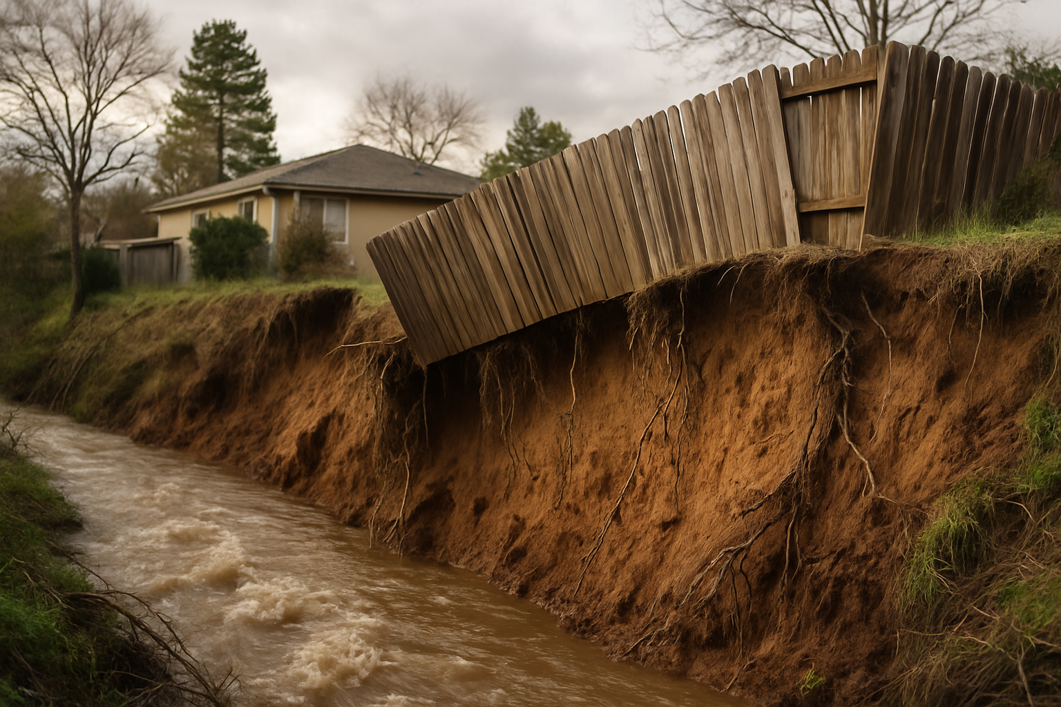
One homeowner on Londonberry Drive in Santa Rosa described it as watching their backyard disappear in slow motion. Every winter, heavy rains pushed Mark West Creek higher, and every spring, there was less usable land behind the house. By the time they reached out, they were asking a question I hear more than people might expect: if this keeps going, is the house itself at risk?
The honest answer is yes — and faster than most people think. Once a creek bank steepens past a certain angle, lateral erosion can move toward a structure quickly. It isn’t a gradual, decades-long process. One bad storm season can take what took years to build up and cut it back by several feet.
This article walks through what erosion control on a riparian lot actually involves: which solutions work and when, what permits are required before anyone touches the bank, and what decisions you’ll need to make before a contractor can give you a realistic answer.
Why Creek Bank Erosion in Sonoma County Is Different From a Hillside Erosion Problem
Most erosion problems I work on are slope-related — water running down a graded hillside that wasn’t stabilized correctly. Creek bank erosion is a different animal. The force acting on your property isn’t just gravity and rain. It’s moving water with hydraulic pressure, and it works on the toe of the bank first, undercutting the face before anything visible happens at the top.
Sonoma County’s clay soils make this worse. Clay holds together when it’s dry, which can mask how much undermining is already happening. Then the rains come — and after the winter 2025–2026 storm season, which brought back-to-back atmospheric rivers and pushed the Russian River into flood stage near Guerneville — saturated clay loses cohesion fast. Bank faces that looked stable in October can slump badly by February.
FEMA released updated preliminary flood maps for the Santa Rosa Creek watershed in January 2026, identifying revised flood hazards along 12 streams throughout Sonoma County. If your property backs up to Mark West Creek, Laguna de Santa Rosa, Colgan Creek, or a similar waterway, those map changes may affect your building regulations and insurance situation — on top of whatever active erosion you’re already dealing with.
Understanding what happens to a hillside when erosion goes unfixed for even one winter gives you a better baseline for how quickly things can escalate once the bank face steepens.
The Permit Reality Most Homeowners Don’t Know Until They’re Mid-Conversation
This is where I see people get surprised. Creek bank work in Sonoma County isn’t just a grading permit situation. Depending on the watercourse classification and the type of work proposed, you may need approval from three separate regulatory agencies before any excavation or armoring begins.
Here’s who potentially has jurisdiction:
- Army Corps of Engineers — if the creek is a jurisdictional waterway (which most named creeks in Sonoma County are), any work in or adjacent to the ordinary high water mark may require a Section 404 permit or a Nationwide Permit verification
- California Department of Fish and Wildlife (CDFW) — a Streambed Alteration Agreement under Section 1602 of the Fish and Game Code is required for work that alters the bed, bank, or channel of a stream
- Sonoma County Permit and Resource Management Department (PRMD) — a grading permit is required for cuts or fills exceeding 50 cubic yards, and creek-adjacent work often triggers additional review under local riparian corridor policies
None of these agencies coordinate with each other automatically. The Corps may have different timing requirements than CDFW. PRMD may require a biological assessment before they’ll accept your application. Getting all three aligned and moving in the right order is genuinely one of the harder parts of this type of project — and it’s also exactly where a contractor without local experience tends to slow a project down or stall it entirely.
A solid civil site plan is almost always the starting point for pulling any of these permits together. It’s not optional on creek bank work.
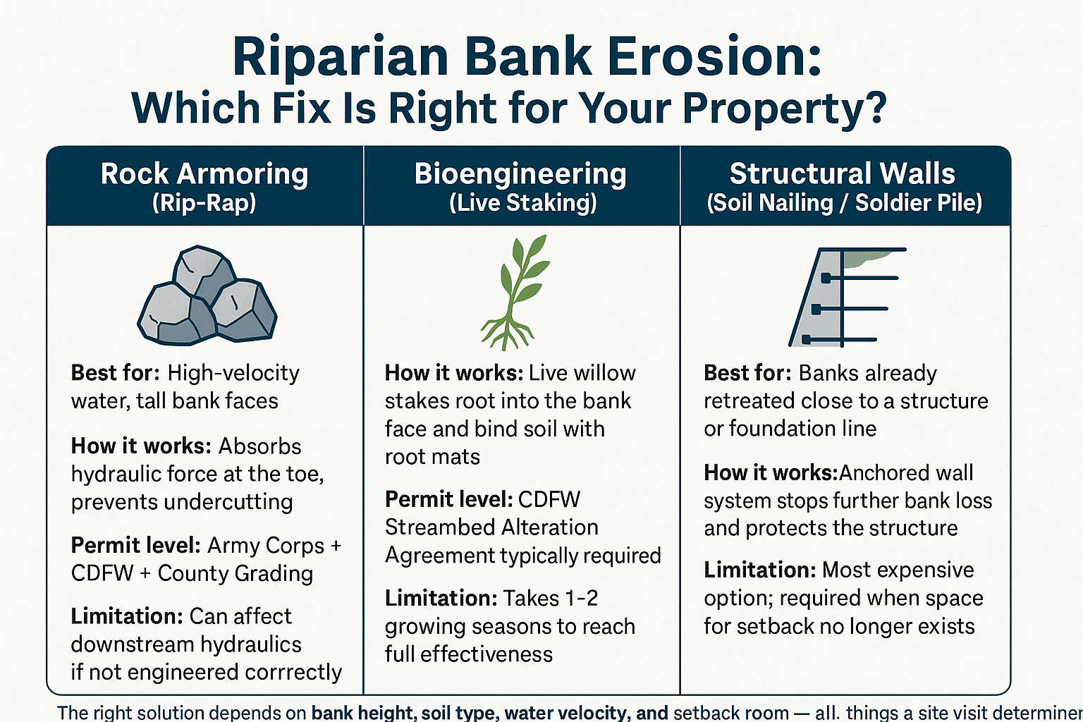
Three Approaches to Riparian Bank Erosion — and When Each One Applies
Not every eroded creek bank calls for the same fix. Here’s a simple breakdown of the three main approaches, what each one does, and the conditions that make it the right call.
How to Think About Which Solution You Actually Need
I’ll be direct: no contractor can tell you the right approach from a phone call. The decision depends on factors that require eyes on the site — bank height, soil type, how fast water moves through that section of creek, and how much horizontal distance exists between the current bank face and your structure.
That said, here’s the general decision framework I work through on riparian sites:
Rock armoring (rip-rap) is the most common hard solution for active, high-velocity erosion. Large angular rock is placed at the toe and face of the bank to absorb hydraulic force and prevent further undercutting. It stops bank loss reliably. But it requires permits from all three agencies, and if it’s not designed to account for downstream hydraulics, it can push erosive force onto a neighbor’s property.
Bioengineering approaches — most commonly live willow staking combined with root-mat reinforcement — work well on lower-velocity banks where the erosion rate allows time for root systems to establish. CDFW tends to prefer these methods because they restore native riparian habitat while solving the erosion problem. The drawback is that they take a growing season or two to reach full effectiveness, so they’re not the right answer if your bank is actively moving toward a foundation.
Soil nailing or soldier pile walls come into play when a bank has already retreated close enough to a structure that there isn’t room for a setback or a gentler solution. These are engineered structural systems, and they’re the most permit-intensive and expensive option. But when a foundation line is at stake — which was exactly the concern the Santa Rosa homeowner described — they’re sometimes the only answer that addresses the real risk.
The 5 signs your property isn’t ready for a major storm season lays out some of the earlier warning signs that a drainage or erosion situation is escalating — worth reading if you’re not sure how serious your bank condition actually is.
Riparian Erosion Control at a Glance: Key Decision Factors
These are the site conditions that drive the solution selection on a creek bank project. A site visit is the only way to assess them accurately.
| Factor | Why It Matters | Who Assesses It |
|---|---|---|
| Bank height | Taller banks require more structural solutions; bioengineering has height limits | Contractor site visit |
| Water velocity | High-velocity flows require hard armoring; bioengineering won’t hold under fast water | Contractor + hydrologist if needed |
| Soil type | Sonoma County clay behaves differently than sandy loam — affects how solutions are installed | Contractor + soils report |
| Setback distance | How far the bank face is from your structure determines urgency and solution type | Contractor site visit |
| Watercourse classification | Determines which agencies have jurisdiction and which permits are required | CDFW + Army Corps review |
| Existing erosion rate | Active rapid loss = emergency timeline; slow chronic loss = more solution options available | Contractor + site history |
What the Permit Process Actually Looks Like in Practice
I want to give you a realistic picture of timing, because this is where projects stall if nobody manages the process carefully.
A CDFW Streambed Alteration Agreement (the 1602 permit) typically takes 30 to 60 days from a complete application, though complex sites or sites with sensitive species habitat can run longer. The Army Corps Nationwide Permit process can move faster for smaller projects that qualify under standard categories — sometimes 30 to 45 days — but a full Individual Permit takes considerably longer and is only triggered on larger, more impactful projects.
Sonoma County PRMD’s grading permit review timeline varies based on current workload and whether the project triggers additional reports like a geotechnical study or biological assessment. Expect 4 to 8 weeks as a reasonable range for a straightforward riparian grading application, longer if the site triggers special review.
The practical implication: creek bank work is not a call-us-Monday, start-next-week situation. If you want work completed before the following winter storm season, you need to start the site assessment and pre-application process in late spring or early summer at the latest. Properties along Mark West Creek, Colgan Creek, and Laguna de Santa Rosa that saw elevated flow damage in the winter of 2025–2026 are already behind schedule for repairs before next fall.
For context on how grading and drainage on a complex site can interact with property stability more broadly, the how to tell if your property was graded right article walks through some of the warning signs that the underlying site conditions are contributing to surface problems.
Frequently Asked Questions About Creek Bank Erosion Control in Sonoma County
Do I really need permits just to put rocks on my creek bank?
Yes, almost certainly. If the creek is a named waterway or a jurisdictional stream under federal or state rules — which most creeks in Sonoma County are — placing rock, soil, or any other material in or adjacent to the bank requires permits from CDFW, and likely the Army Corps of Engineers as well. Doing the work without permits can result in stop-work orders, fines, and mandatory removal of whatever you installed. The permit process exists partly to prevent property owners from solving their own erosion problem in a way that makes their downstream neighbor’s problem worse.
Can I plant willows along my creek bank myself to stop the erosion?
Planting on the top of the bank, away from the water’s edge, is generally fine without permits. But live staking directly into the bank face — which is what actually controls erosion — involves work in the streambed zone and typically requires a CDFW Streambed Alteration Agreement even when no heavy equipment is used. It’s worth confirming with CDFW before you start, because the consequences of unpermitted streambed work can be significant.
How much does creek bank erosion control cost?
Honestly, it varies too much for a useful number without a site visit. A small bioengineering project on a low-velocity bank might run in the range that a single homeowner can absorb. A rip-rap armoring project with engineering, permits, and heavy equipment on a tall bank face is a different cost category entirely. The permit process itself carries filing fees and potentially the cost of reports like geotechnical assessments or biological surveys. What I’d say is: the cost of doing nothing compounds every winter, and the longer active erosion goes unchecked, the fewer solution options you have left.
My bank is already close to my house. Is it too late for a non-structural solution?
Possibly, but it depends on how close and how fast the bank is moving. If there’s still meaningful horizontal distance between the current bank face and your foundation line, a well-designed hard armoring solution like rip-rap can stop further loss without requiring a full structural wall. If the bank has retreated to within a few feet of the structure, a soil nailing or soldier pile wall may be the only option that actually protects the building. A site assessment is the only way to give you an honest answer.
Will the county or city help pay for erosion control on my creek bank?
In most cases, no — riparian bank repair on private property is the property owner’s responsibility. Some grant and flood mitigation programs exist at the state and federal level for qualifying properties, but they are competitive, slow, and often targeted at agricultural or public lands. One homeowner near Mark West Creek specifically noted that the city and county had not been willing to assist with their situation. It’s worth asking your county supervisor’s office about any current programs, but most property owners fund this work themselves.
How do the new FEMA flood maps affect my creek bank repair project?
FEMA’s January 2026 preliminary flood maps for the Santa Rosa Creek watershed revised the flood hazard designations along 12 streams in Sonoma County. If your property was reclassified into a higher-risk flood zone, it may affect what Sonoma County PRMD requires before approving a grading permit for bank repair work — and it may also trigger flood insurance requirements from your lender. These maps are still preliminary, so there’s a comment period during which property owners can contest inaccurate designations. A licensed contractor with local permit experience can help you understand what the reclassification means for your specific project.
Ready to Get a Real Answer About Your Creek Bank?
If your property backs up to a creek in Sonoma County and you’ve been watching the bank edge get closer every winter, the right starting point is a site visit — not a phone estimate. Our team at DW Excavation has worked on riparian bank projects throughout Santa Rosa, Windsor, Healdsburg, and the surrounding unincorporated areas, and we know the permit landscape well enough to give you a straight answer about what your project actually requires. Call us at 707-601-9091 or reach out through the contact page at dw-excavation.com to get the conversation started.