
A site plan is the official, to-scale blueprint of your property. It’s the master guide that lays out everything from property lines and building locations to utility lines and crucial drainage paths. This document is almost always created by a licensed professional—like a surveyor, civil engineer, or architect—and it’s the key to getting a permit for most construction projects.
Why You Suddenly Need a Site Plan for Your Project

If you’re building a shed, ADU, or even regrading part of your yard, you might be shocked to learn that your city requires a detailed site plan—even for something “simple.” Many first-timers run into delays because they didn’t know this was needed.
This isn’t just some simple sketch you can draw up yourself. A site plan is a foundational document ensuring everyone on your project—from the excavation contractor to the final builder—is working from the same official playbook.
Common Missteps That Cause Delays
People often assume that if a structure is “under permit size,” they can skip planning. But zoning, setbacks, water flow, and access paths still need to be shown. Using an outdated online template or skipping a survey can lead to permit denials.
This common misstep is a major source of frustration and can stall a project before it even starts. Local agencies still need to verify that your plans comply with a long list of regulations, regardless of project size.
More Than Just a Drawing
Think of a proper site plan as a technical document that visualizes your entire project in the context of your property’s existing conditions. It’s more than just a sketch—it’s a document that local agencies use to protect safety, environment, and neighboring properties.
A professional plan must accurately show:
- Zoning and Setbacks: How far your new structure will be from property lines.
- Water Flow and Drainage: Where rainwater is going to go, so you don’t flood your property or your neighbor’s.
- Utility Lines: The precise location of existing and proposed water, sewer, and electrical lines.
- Slopes and Access: How vehicles and people can safely get to and from the site.
In California, especially post-2024, counties now require site plans that include grading and drainage elements—even for smaller projects—because of new stormwater retention and wildfire regulations [Smart Cities Dive, 2025].
Site Plan At-a-Glance: Key Elements and Purpose
| Key Element | What It Shows | Why It Matters for Permits |
|---|---|---|
| Property Lines | The legal boundaries of your lot. | Confirms your project is actually on your land and not encroaching on neighbors. |
| Setbacks & Easements | Required distances from boundaries; areas where others have access rights. | Proves you are complying with local zoning laws that dictate building placement. |
| Existing & Proposed Structures | Footprints of all buildings, driveways, and hardscapes. | Shows how the new construction fits into the existing layout and calculates lot coverage. |
| Topography & Grading | The slope and elevation of the land. | Essential for ensuring proper drainage, foundation stability, and accessibility. |
| Utilities | Location of water, sewer, gas, and electric lines. | Prevents accidental damage during excavation and ensures safe, legal connections. |
| Drainage Plan | How water will flow off the property. | Required to show you won’t cause flooding or erosion issues on-site or for neighbors. |
Each piece of this puzzle tells the planning department that you’ve done your homework and your project is safe, compliant, and well-thought-out.
What to Do Instead: Get Professional Help Early
Get professional help early. A proper site plan should include slopes, utility lines, drainage paths, and code-compliant layouts.
DW Excavation specializes in navigating local permit requirements in Sonoma and Monterey counties. We handle site surveys, grading plans, and know what each planning department looks for—saving you time, headaches, and rework. Understanding these requirements is the first step, and you can learn more about how our zoning services can streamline your project.
Decoding the Key Elements of a Site Plan

A well-crafted site plan is the official story of your project, told in a language that local planning departments understand. Think of it as the complete anatomy of your property, where every line and symbol ensures your build is safe and legal.
Each part of the plan answers a critical question for city and county officials. They’re checking that your project respects legal boundaries, won’t harm the environment, and won’t create a headache for you or your neighbors down the road.
Property Lines and Boundaries
The absolute first layer of any site plan is locking down the legal boundaries. This is the non-negotiable foundation. A licensed surveyor digs into official records and uses physical markers to create a base map showing the exact size and shape of your lot.
This step single-handedly prevents the costliest mistake in construction: accidentally building on a neighbor’s land.
Existing Topography and Features
Before you can show what you plan to build, the site plan has to document what’s already there. This means mapping the topography—the natural slopes, hills, and dips in your land. It also involves pinpointing the location of existing structures, mature trees, and anything else significant.
This “before” picture is vital. A planner needs to see what the land looks like now to understand the full impact of the “after.”
Proposed New Structures and Dimensions
This is where your vision comes to life on paper. This section lays out the precise footprint, dimensions, and location of any new buildings, ADUs, driveways, or patios. Every new element is drawn perfectly to scale.
Officials use these measurements to check things like lot coverage percentages and confirm the scale of your project is right for the property.
Setbacks and Easements
Every property is governed by invisible boundaries called setbacks and easements. Setbacks are mandatory buffer zones that dictate how far a structure must be from the property lines. Easements are legal rights-of-way that give utility companies or neighbors permission to access your land.
Your site plan has to clearly show that your new structures respect these restrictions. Building inside a setback is a guaranteed way to get a stop-work order.
Site plans are legal lifelines packed with critical data. They specify setbacks, which often range from 10 to 50 feet from boundaries, and outline grading to achieve proper drainage slopes, typically between 2% and 5%. These details are indispensable for construction projects worldwide. Learn more about the technical details of site planning from Digital Blue Foam.
Utility Line Locations
The plan must map out all utility lines, both existing and proposed. This includes water, sewer, gas, electricity, and communications. During excavation, knowing the exact location of underground lines prevents dangerous—and extremely expensive—accidents.
It also shows planners how the new structures will connect to public services, confirming the local infrastructure can handle the new load.
The Critical Grading and Drainage Plan
This might be the most scrutinized part of the whole plan, especially here in California. The grading and drainage plan details exactly how the land will be reshaped to control the flow of water. It shows proposed elevations and slopes designed to guide rainwater away from foundations.
With strict new stormwater regulations in places like Monterey and Sonoma counties, this plan isn’t a suggestion—it’s a dealbreaker. A professionally engineered grading plan is your best defense against future water damage. Discover more about integrating erosion control and water management solutions in our detailed guide.
The Licensed Professionals Who Create Your Site Plan
So, now that you know what goes into a site plan, your next question is probably, “Who actually makes one?” This isn’t something you can sketch out on graph paper. A real site plan is a legal document that has to be prepared by a licensed professional.
Understanding who is qualified to draft and stamp these plans is crucial. In California, only specific experts have the authority to do this work, ensuring every detail complies with local zoning ordinances and building codes.
Who Can Help Me Make a Site Plan?
Creating a site plan is like putting together a specialized crew. Each professional brings a unique skill set to the table, and your project’s needs will dictate who you need to bring on board.
Here are the primary roles:
- Land Surveyors: Your first call, almost always. A licensed land surveyor creates the foundational base map, locating your property boundaries, easements, and existing topography.
- Civil Engineers: These are your experts in grading, drainage, and utilities. A civil engineer designs the precise slopes to guide water away and maps out connections for new water and sewer lines.
- Architects: An architect places the structure they’ve designed on the surveyor’s map, making sure it meets all setback requirements and works with other site features.
- Landscape Architects: If your project involves significant outdoor elements, a landscape architect designs the “softscapes” (plants) and “hardscapes” (patios and retaining walls).
Knowing Who to Call and When
The right professional depends on your project. Building a simple ADU on a flat lot? A land surveyor and an architect might be all you need.
But if you’re planning a new custom home on a sloped property in Monterey County, you will absolutely need a civil engineer to create a solid grading and drainage plan.
Understanding who can help is essential, as only licensed architects, engineers, landscape architects, or land surveyors are typically authorized to prepare site plans. In the U.S., the National Council of Examiners for Engineering and Surveying (NCEES) oversees this rigorous licensing, with over 500,000 certified professionals as of 2025. You can discover more insights about the step-by-step process of site plans on qebimservices.com.
How DW Excavation Fits into the Process
While we don’t stamp the final plans, DW Excavation’s engineering-integrated approach makes us a vital partner. We work side-by-side with civil engineers and surveyors across Sonoma and Monterey counties. Our practical knowledge of local soil conditions helps provide critical feedback during the design phase.
This collaboration ensures the engineer’s plan is not just compliant but also practical and cost-effective to build. By bridging that gap, we help prevent expensive revisions and smooth the path from plan to permit. Check out our guide on how to find the right site planning experts in Monterey for more local insights.
Navigating the Site Plan Process from Start to Finish
Knowing what a site plan is and who makes it is a great start. But understanding the journey from a simple idea to a permit-approved document is where the real confidence comes from. The process follows a logical path.
The whole point is to move from a rough concept to a highly detailed plan that your local building department—whether in Sonoma or Monterey County—will approve without a hitch.
Step 1: Defining Your Project Scope
Before a single line gets drawn, you need a clear vision. What are you building? A small backyard shed? A multi-room ADU? The size and complexity of your project will determine how detailed your site plan needs to be.
This is the time to gather your ideas, inspiration photos, and a rough budget. Having this clarity upfront helps you communicate your vision to the professionals who will turn it into a reality.
Step 2: Hiring a Land Surveyor for a Base Map
This is where things get official. Your first call is almost always to a licensed land surveyor. They’ll perform a topographic survey to create an accurate base map of your property, documenting boundaries, structures, elevations, and easements.
Think of this survey as the canvas for your entire project. Without this precise, legally binding foundation, no architect or engineer can even begin to design.
Step 3: Designing the Plan with an Architect or Engineer
With the surveyor’s base map ready, it’s time to bring in an architect or civil engineer. An architect will focus on designing the building, placing its footprint on the map to meet all zoning rules.
A civil engineer handles the technical side of the site. They design the crucial grading and drainage plan and map out utility connections. For any project on a sloped lot, the civil engineer’s role is absolutely vital.
This infographic breaks down how these key players work together to bring your site plan to life.
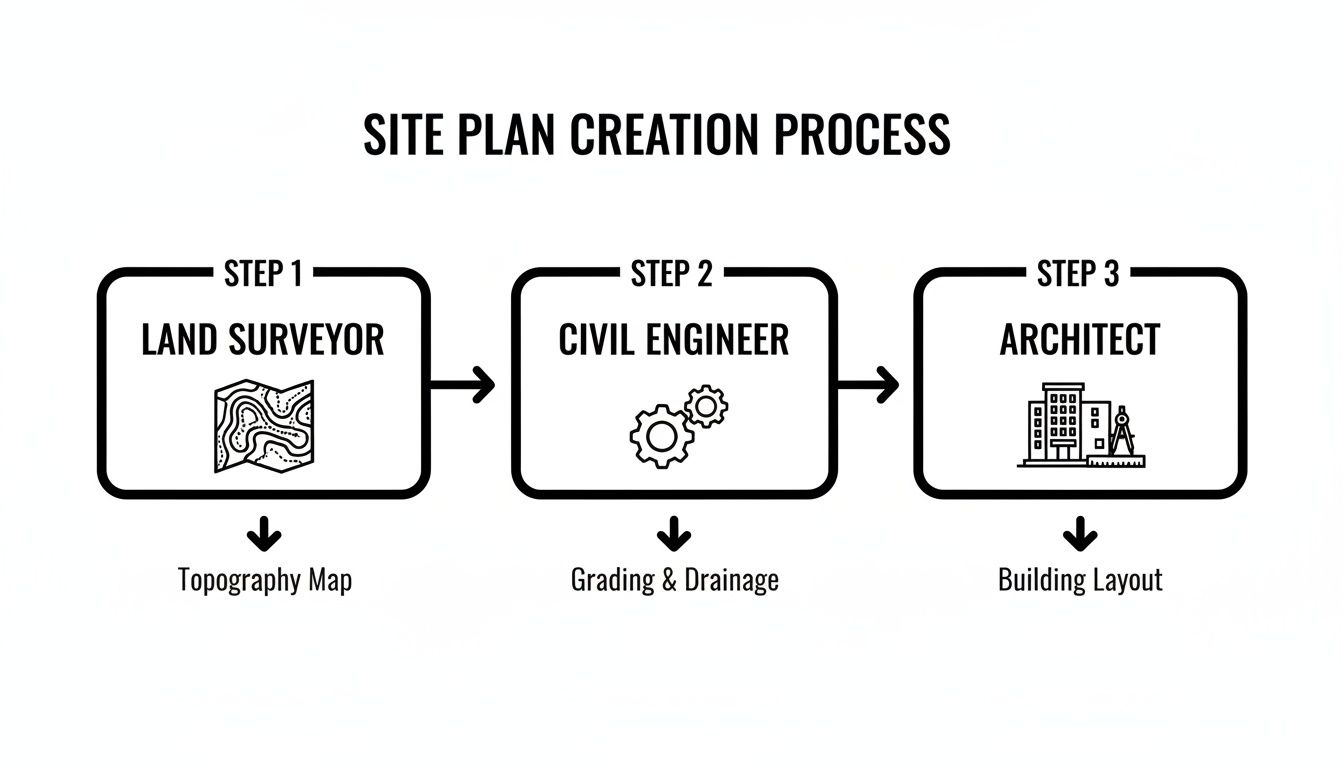
The process flows from the surveyor’s foundational map to the engineer’s technical design and the architect’s structural layout. To help clarify these roles, here’s a quick breakdown of who handles what.
Who Does What in the Site Plan Process
| Professional | Primary Role | Key Deliverable |
|---|---|---|
| Land Surveyor | Establishes the legal and physical baseline of the property. | A certified topographic survey or “base map.” |
| Architect | Designs the building and ensures it fits the site according to zoning laws. | Building footprints, floor plans, and elevations. |
| Civil Engineer | Designs site infrastructure like grading, drainage, and utilities. | A stamped grading and drainage plan. |
| Landscape Architect | Designs outdoor spaces, planting, and hardscapes. | A landscape plan showing plants, paths, and features. |
| Excavation Contractor | Physically moves the earth to match the engineer’s grading plan. | A properly graded and prepared construction site. |
This table makes it clear how each expert contributes a critical piece to the puzzle.
Step 4: Integrating the Grading and Excavation Details
Here’s where the paper plan meets the dirt. The civil engineer’s grading design needs to be translated into a practical excavation strategy. This is where DW Excavation’s engineering-focused approach really shines.
We work directly with your engineer to ensure their plan is buildable and cost-effective. This partnership, a key part of our excavation services on the California Central Coast, makes sure the team on the ground fully understands the design.
Step 5: Reviewing and Revising the Drafts
No plan is perfect on the first go. Once the initial drafts are done, you and all the professionals involved will review them. This is your chance to spot issues and request changes.
It’s far cheaper to move a line on a computer screen than it is to move a concrete foundation. Several rounds of revisions are a normal and essential part of the process.
Step 6: Submitting the Final Plan for Your Permit
With a completed and stamped site plan in hand, the final step is submitting it to your local planning and building department. An official reviewer will go over every detail to confirm it meets all local codes. Once they give it the stamp of approval, you’ll receive your building permit.
Common Site Plan Mistakes and How to Avoid Them
Even the sharpest projects can get bogged down by a few common—and costly—site plan mistakes. Knowing what these pitfalls are ahead of time is the best way to dodge frustrating delays, budget overruns, and permit denials.
The goal isn’t just getting a piece of paper approved. It’s about creating a roadmap that sets your project up for a smooth, efficient build from day one.
Misstep 1: Assuming Your Project Is “Too Small”
This is probably the most frequent error we see. People often think that if they’re just building a shed, a small ADU, or even regrading a section of their yard, they can skip the formal planning process. You might be shocked to learn that your city almost certainly requires a detailed site plan.
Many first-time builders get stuck in permitting limbo simply because they didn’t realize this was a mandatory step. Critical details like zoning compliance, property line setbacks, water flow, and access still need to be officially documented.
Due to new stormwater retention and wildfire regulations, counties now require site plans that include specific grading and drainage elements, even for smaller projects [Smart Cities Dive, 2025]. This increased scrutiny means that what might have passed with a simple sketch five years ago now requires a professionally engineered document.
Misstep 2: Using a Generic Online Template
Trying to save a few bucks by downloading a generic site plan template is a recipe for rejection. These one-size-fits-all documents almost never account for the specific codes and formats required by local jurisdictions like those in Sonoma and Monterey counties.
Every planning department has its own unique set of rules. A template won’t show the correct setbacks for your zone or include the necessary calculations for a proper drainage strategy. You can get a better sense of what goes into a compliant plan by reading our guide to fixing drainage and grading problems.
Misstep 3: Skipping a Professional Survey
Another tempting but dangerous shortcut is using an old property survey or trying to measure the boundaries yourself. This is a massive gamble. An outdated survey won’t reflect current conditions, and a DIY measurement holds zero legal weight.
Without a recent, stamped survey from a licensed professional, your entire plan is built on a house of cards. This single mistake can spiral into severe consequences:
- Immediate Permit Denial: The planning department will reject any plan not based on a certified survey.
- Stop-Work Orders: If a boundary error is found after construction begins, the city can shut your project down instantly.
- Costly Redesigns: Discovering your new foundation is over the property line means tearing it down and starting over.
The solution is simple: get professional help involved early. A proper site plan is far more than a sketch—it’s a technical document that protects you. DW Excavation specializes in navigating these local requirements, ensuring your plan is built right from the ground up.
Breaking Ground with Confidence in California
Moving from an idea on paper to actually breaking ground can feel like a huge leap. But it doesn’t have to be intimidating. A professional site plan isn’t just another box to check—it’s the true foundation of any successful build.
This is especially true in places like Sonoma County and Monterey County, where local rules are strict. Going it alone isn’t just tough; it’s a gamble. The risks are real, from sudden permit denials to expensive stop-work orders.
The DW Excavation Advantage
This is where having a team that bridges the gap between engineering and execution becomes your most valuable asset. At DW Excavation, we don’t just move dirt. We take the technical specs from a civil engineer’s design and translate them into precise, on-the-ground action.
Our years of working with planning departments across the California Central Coast mean we know what they’re looking for. We work right alongside your surveyor and engineer, giving them practical feedback to ensure your grading plans are compliant, practical, and cost-effective.
A proper site plan is more than a sketch—it’s a legal document that local agencies use to protect public safety, the environment, and neighboring properties. It’s your ticket to breaking ground faster and with total confidence.
Planning a shed, ADU, or yard upgrade? If you’re in the California Central Coast, let DW Excavation guide you through the site planning process—so you can break ground faster, with confidence.
Frequently Asked Questions About Site Plans
Here are some of the most common questions we get from homeowners and builders about the site planning process.
How much does a professional site plan cost in California?
The cost depends on your project’s complexity and the size of your lot. For a simple project, like a deck on a flat lot, you might start around $1,500. For a new custom home or an ADU on a sloped property in Sonoma County, costs can range from $5,000 to $15,000 or more.
How long does it take to get a site plan made?
The timeline is influenced by professional schedules and project demands. Typically, expect the process to take 4 to 8 weeks from hiring a surveyor to holding a permit-ready plan. This includes the survey (1-2 weeks), design work (2-4 weeks), and revisions (1-2 weeks).
Can I draw my own site plan for a permit?
For very minor projects, like a small garden shed, a hand-drawn plot plan might be accepted. However, in California, any project involving a new foundation, significant earthmoving, or a permanent structure will require a site plan stamped by a licensed professional, such as a surveyor, civil engineer, or architect.
What’s the difference between a site plan and a survey?
It’s simple: a survey shows what is, while a site plan shows what will be. A survey is an official map of your property’s existing conditions (boundaries, elevations, easements). A site plan uses that survey as a base and adds all the proposed changes (new buildings, driveways, grading).
Do I really need a new site plan just to regrade my yard?
In many parts of California, yes. If your grading work will change how water drains, involves moving a lot of soil, or is on a hillside, most counties will require a formal grading and drainage plan. This is a specialized site plan focused on managing stormwater and preventing erosion.
Ready to turn your vision into a reality without the permit headaches? The team at DW Excavation, LLC specializes in navigating the complex site planning and development process in Sonoma County, Monterey County, and across the California Central Coast. Let us help you get your project started on solid ground. Learn more about our site development services.