
Your Santa Rosa project can look simple on paper and still run into permit trouble before excavation starts.
A homeowner submits a plan for an ADU, drainage repair, or foundation work. The drawing shows the rough location of the improvement, but it leaves out spot elevations, drainage flow, utility conflicts, or field conditions that do not match the parcel record. City or county reviewers catch the gaps quickly. What felt like a routine submittal turns into revisions, added consultant costs, and weeks of delay.
That happens because residential site plans in Santa Rosa and the rest of Sonoma County are reviewed more closely than many owners expect. Reviewers are not only checking where the structure sits. They are looking at grading impacts, runoff, access, setbacks, utility locations, erosion control, and whether the plan matches local code and permit requirements.
We see the same problem across first-time submittals. Homeowners start with a sketch, an old survey, or a generic plan set that does not reflect how the work will be built. Then the permit process exposes every missing piece.
Current development activity adds pressure to that review process. Santa Rosa continues to process housing growth and infill work, as reflected in the City of Santa Rosa development activity tracking and housing reporting, which keeps permit staff focused on detail and compliance from the start (City of Santa Rosa development and housing information). Vague plans, outdated measurements, and disconnected grading notes usually lose time first.
For smaller residential jobs, that surprises people the most. A short retaining wall, a driveway rework, or a backyard structure can trigger more site questions than the owner expected. If you are still unsure whether a site plan is needed for a small project, that misunderstanding is often the first problem to fix.
The good news is that these mistakes are predictable. More important, they are preventable when the plan is built around real site conditions, local review standards, and the way the project will move through excavation and permitting.
1. Assuming site plans are only for large commercial projects
A Santa Rosa homeowner decides to build a small backyard structure, improve drainage along one side yard, or repair a foundation corner. The work feels modest, so the plan set stays modest too. A simple sketch goes in with the permit package, and that is usually where the delays start.
On residential jobs, a site plan is not a formality reserved for shopping centers or apartment projects. It is the document reviewers and contractors use to understand how the work fits the lot, what existing conditions affect construction, and whether the project can be approved without rounds of corrections. Small projects often fail here because the owner treats the plan like a label for the job instead of a buildable layout.
Small residential work still gets close scrutiny
Some of the hardest review comments show up on jobs homeowners consider minor. An ADU on a tight parcel can create layout conflicts. A short retaining wall can raise slope questions. Foundation repair can trigger concerns about drainage, nearby improvements, and how the repair will be executed in the field.
That is why a plat map or rough sketch rarely carries a residential permit very far. Review staff are not only checking what you want to build. They are checking whether the drawing reflects the conditions on site well enough to approve grading, access, drainage paths, and inspection points without guessing.
Santa Rosa and Sonoma County also see plenty of remodels, additions, and rebuild work on older lots. Those properties tend to have layered conditions from past improvements, partial records, and site changes that never made it onto a clean drawing. A geospatial analysis mindset helps here. Better location data leads to better decisions, especially on small parcels where a few feet can change the permit path.
A useful starting point is DW Excavation’s guide on do I need a site plan even for a small project.
What works better than a simple sketch
The stronger approach is to prepare the site plan as a job document from the start. That means it should answer practical field questions, not just identify the proposed improvement.
A few habits separate permit-ready plans from plans that stall:
- Confirm current site conditions: Older surveys, listing photos, and aerial images often miss changes made by prior owners.
- Show how the work will be constructed: Reviewers want enough detail to understand where work begins, how crews access it, and how the site functions during construction.
- Include real dimensions and relationships: Small residential lots leave little room for assumptions, especially where improvements sit close to each other.
- Coordinate known infrastructure early: Homeowners dealing with older properties often run into buried service issues later, which is one reason articles on underground pipe repair in older homes keep resonating with owners across Northern California.
Here is the pattern we see in the field. A homeowner settles on an ADU footprint, lines up excavation, and assumes the permit is mostly paperwork. Then the review process exposes missing dimensions, unclear site relationships, or a layout that does not match actual conditions. The revision itself is not the biggest problem. The lost time is.
If the site plan does not show how the job will be built and reviewed on the actual lot, it is not ready for submittal.
Experienced local coordination helps because residential permitting in Santa Rosa is rarely just about the structure itself. DW Excavation often helps close that gap by building permit-ready site plans around actual field conditions, realistic construction sequencing, and the review issues that commonly hold up first-time submittals.
2. Overlooking existing underground utilities in site planning
A homeowner stakes out a new driveway or ADU pad, sees clear ground, and assumes the work area is ready. Then the first trench exposes an old sewer lateral, a private electrical feed, or a gas line that never made it onto the sketch. That is how a simple permit set turns into field changes, utility calls, and delays no one budgeted for.
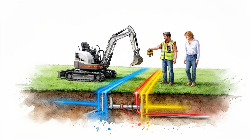
Public markings are only part of the picture
Santa Rosa’s older neighborhoods make this mistake expensive. USA North 811 markings help identify many public lines, but they do not give homeowners a full map of private laterals, abandoned runs, irrigation sleeves, undocumented remodel work, or service reroutes added decades ago.
A permit reviewer may not catch every buried conflict on paper. The crew in the yard will.
That is why a workable site plan shows more than proposed improvements. It should reflect known utility paths, suspected conflict zones, and where excavation has to slow down for potholing or hand exposure. On infill lots with tight side yards and multiple generations of additions, that level of detail often decides whether the job stays on schedule.
A good planning process uses better location data before anyone starts digging. The same logic behind geospatial analysis applies here. Better information at the front end leads to fewer field corrections later.
Underground issues often overlap with pipe condition. Older private sewer and drain lines are frequently shallow, brittle, poorly documented, or all three. DW Excavation discusses that pattern in why Salinas homes need underground pipe repair more than ever. The local lesson applies in Sonoma County too. Buried infrastructure on aging residential lots is rarely as clean or as predictable as the original plan set suggests.
Show utility conflicts before the permit set goes out
Homeowners usually focus on where the new work will sit. Contractors also need to know how the work will cross what is already there.
That includes service crossings, trench routes, meter locations, cleanouts, utility separations, and the areas where standard excavation is not appropriate. In some cases, trenchless installation methods such as horizontal directional drilling can reduce surface disruption on built-out residential sites, but only after the known conflicts are located and the route is feasible. It is a planning decision, not a last-minute rescue.
For homeowners trying to avoid revisions and surprise costs, the practical steps are straightforward:
- Mark all known service lines: Water, sewer, gas, electric, telecom, irrigation, and any private conduit or sleeves.
- Document field evidence: Photograph paint marks, cleanouts, valve boxes, meters, and exposed utilities before they disappear under staging or demolition.
- Call out conflict zones on the plan: Show where hand digging, test holes, or limited-access excavation will be required.
- Check drainage infrastructure too: Area drains, yard drains, and downspout connections often intersect with proposed work. Problems there can affect both utility routing and grading, especially if the property already needs drainage solutions for homes.
- Verify shared conditions: Older subdivisions and shared driveways sometimes hide crossed services or informal utility placements that do not appear in county records.
Clean drawings do not protect a project from buried surprises. Field verification does. The homeowners who get permits approved faster in Santa Rosa are usually the ones whose site plans reflect the lot they have, not the one they assumed was underground.
3. Ignoring drainage and stormwater management in site planning
A Santa Rosa permit set can look clean on paper and still fail in the field the first time a winter storm hits. The usual problem is simple. The plan shows where the structure goes, but it does not show where the water goes.
In this area, reviewers and contractors look for that gap early. Older neighborhoods, clay soils, hillside lots, and hard winter rain create runoff problems fast, especially after grading changes even slightly.

Water problems usually start with grading decisions
A yard can look flat enough to the homeowner and still drain poorly after construction. A new slab cuts off an old flow path. A trench spoils the slope. Fill gets placed without a clear outlet. Then the first serious storm sends water toward the foundation, under a fence, or onto the neighbor's side yard.
That is why drainage has to be part of the site plan before excavation starts, not something figured out after the forms are in. On local residential work, small grade shifts cause many of the drainage failures we see. A few tenths of a foot in the wrong place can turn a side yard into a collection point.
Homeowners dealing with standing water or wet crawlspace and slab conditions can get background on practical drainage solutions for homes. The same principle applies during planning. Water needs a controlled path from the start.
The plan needs to model water, not just structures
A usable site plan answers three questions clearly. Where does runoff start. Where will it travel after the new work is built. Where will it discharge without creating a new problem.
On Santa Rosa residential lots, that usually means showing:
- Existing grades and low points: Especially around foundations, side yards, patios, and driveway edges
- Finished drainage routes: Swales, area drains, trench drains, inlets, rock trenches, or other planned collection points
- Protection at structures: How runoff will be directed away from slab, footing, and retaining areas
- Temporary erosion controls: How disturbed soil will be stabilized during construction so sediment does not wash across the site
Accurate topographic information matters here because shallow depressions and subtle slope breaks are easy to miss on basic drawings. For projects where drainage and foundation planning overlap, the same discipline used in foundation work planning for ADU construction applies to runoff control. The finished grade has to work with the structure, not against it.
If runoff leaves your project without a defined route, it usually creates one in the wrong place.
A common local example is a hillside or semi-hillside ADU. The owner focuses on pad placement, access, and trenching, but the plan does not show how water wraps around the new structure during a heavy storm. The permit review often catches part of it. The field crew catches the rest after staking or excavation. At that point, fixes usually mean revisions, extra drain rock, added inlets, outlet changes, or regrading work that was cheaper to solve on paper.
4. Failing to account for soil conditions and geotechnical issues
A site plan can look clean on paper and still fall apart once the first cut goes in. We see that on Santa Rosa lots where the surface looks dry and workable, but the subsurface tells a different story.
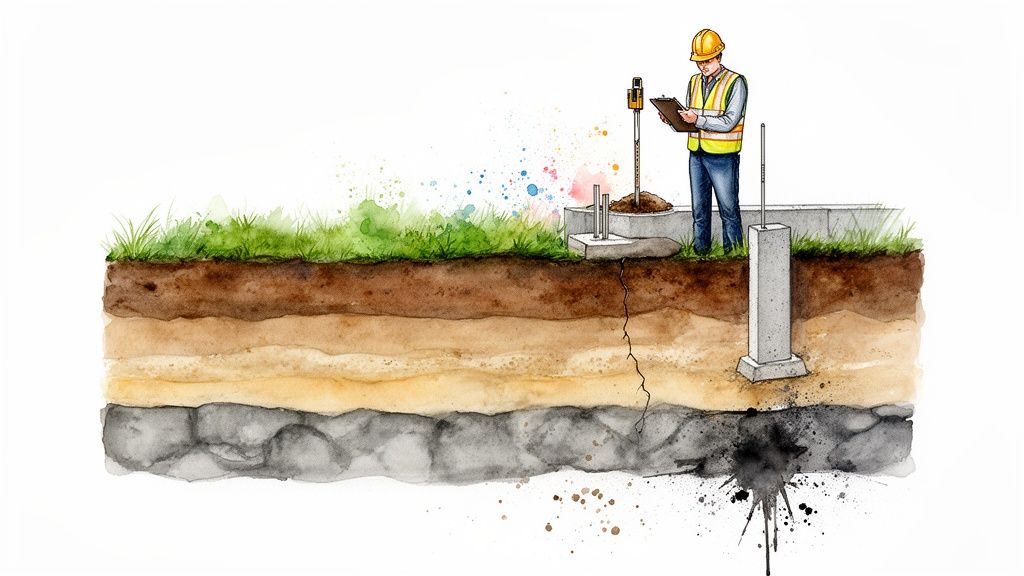
Santa Rosa lots often hide the problem below grade
Older fill, shrink-swell soils, buried debris, perched water, and slope instability do not show up in a basic concept layout. They show up after staking, during excavation, or when the engineer asks for revisions the homeowner did not budget for.
That is a common reason plans get delayed in permit review and in the field. A house pad that works architecturally may still need different overexcavation limits, drainage details, retaining design, or foundation prep once the soil conditions are verified.
On hillside and wildfire-rebuild properties, geotechnical review often intersects with seismic design and slope setbacks. The California Building Standards Commission adopted the 2022 California Building Code, which incorporates updated structural design standards tied to ASCE 7-22 through the state code cycle (2022 California Building Code adoption information). For homeowners, the practical point is simple. If the lot has slope, past grading, signs of settlement, or drainage history, the site plan should be informed by soils work before excavation pricing and foundation assumptions are locked in.
For related foundation concerns on residential build-outs, this DW Excavation guide is worth reviewing: what Monterey ADU builders need to know about foundation work.
Geotechnical input changes cost, layout, and permit risk
Soil reports are not paperwork for the file. They affect real construction decisions, including:
- How deep excavation can go before sidewall support or slope layback changes
- Whether native material can be reused or has to be exported
- How much import fill, moisture conditioning, and compaction testing the job needs
- What kind of footing, slab base, or pier strategy the engineer will accept
- How retaining walls, subdrains, and erosion controls need to be shown on the plan
A common local scenario is an owner who prices the job from surface appearance and a rough layout. Then excavation exposes wet pockets, soft fill, or variable material across the pad. Now the foundation section changes, the retaining concept changes, and the hauling budget changes with it.
That is the trade-off homeowners miss. Early geotechnical work costs money up front, but late discovery usually costs more because it hits the project three times. Design revisions, permit comments, and field changes all stack up.
The better sequence is straightforward. Investigate first, then finalize the site plan, then bid the earthwork. Homeowners trying to avoid review delays should also look at how to get a site plan approved faster, because soil assumptions are one of the easiest ways to end up with corrections after submittal.
In practical terms, the architect’s layout is only part of the answer. The dirt has a vote, and on many Santa Rosa sites, it gets the final one.
5. Not coordinating site plans with local permit and code requirements
A homeowner submits a clean-looking site plan, pays the fee, and expects comments to be minor. Instead, the plan comes back with corrections because the layout does not match current Santa Rosa or Sonoma County review standards. That happens all the time on residential work.
The problem is rarely drafting quality alone. It is coordination. A plan can be neatly drawn and still fail review if it does not reflect the code triggers, agency notes, and field conditions the reviewer checks first.
Local review standards shape what a usable site plan looks like
In Santa Rosa and throughout Sonoma County, small residential projects still get screened for setbacks, drainage paths, grading scope, access, easements, and utility conflicts. Homeowners often miss that because they are looking at what fits on the lot, while the reviewer is checking what is allowed on the lot under current rules.
Older surveys, old listing sketches, and aerial screenshots cause a lot of trouble here. They can make a parcel look more buildable than it is today, especially after zoning updates, wildfire-related requirements, access constraints, or drainage limitations are applied. By the time the plan reaches plan check, the mismatch shows up in comments.
That is why permit rejections often start before anyone argues about construction details. The layout itself is based on stale assumptions.
For homeowners trying to cut down review time, how to get a site plan approved faster explains the approval process in practical terms.
Permit-ready means the reviewer can verify the job quickly
Reviewers are looking for a plan they can clear, not one they have to interpret. If key information is missing or conflicts with local requirements, the project stalls while comments go back and forth.
On residential submittals in this area, the common problem points include:
- Current setbacks, easements, and property line verification
- Grading limits and how runoff will be handled on site
- Drainage, erosion-control, and stormwater notes
- Fire access, driveway geometry, or hillside restrictions where they apply
- Utility locations and potential routing conflicts
- Lot coverage, zoning limits, and any overlay requirements
There is a practical trade-off here. Homeowners can spend a little more time coordinating the plan before submittal, or spend much more time responding to corrections after submittal. The second option usually costs more because the architect, engineer, contractor, and owner all end up revising the same sheet set in stages.
DW Excavation sees this issue most often when a concept plan gets treated like a permit plan. They are not the same document. A permit plan has to work for the city reviewer, the inspector, and the crew building from it.
The strongest site plans answer code questions before the agency asks them.
6. Underestimating project complexity and material volumes
A Santa Rosa homeowner approves a small grading allowance because the yard “only needs a little leveling.” Once staking starts, the crew finds cross-slope, deeper trenching, export loads, and a retaining condition that never made it into the early numbers. The plan did not fail because the project was large. It failed because the quantities were guessed.
That mistake shows up all the time on residential work. Pads, driveway widenings, utility trenches, drainage swales, and backyard retaining walls look simple from the patio. On paper, a few inches of elevation change across a building area can add a surprising amount of cut or fill. On a tight lot, the hauling plan can drive cost almost as much as the excavation itself.
Quantity errors start before the first bucket hits the ground
The problem usually begins with incomplete site information. A concept sketch may show where the improvement goes, but it often does not show how much material has to move, where spoils can be staged, how deep over-excavation might run, or whether imported material is needed to meet compaction and drainage requirements.
In practice, those details affect far more than the grading line item. They affect disposal fees, trucking, equipment access, drainage elevations, wall design, and inspection sequencing. If the quantities are light, the budget is wrong. If the elevations are wrong, the permit set can be wrong too.
Santa Rosa and Sonoma County projects add another layer. Many residential lots are older, irregular, sloped, or constrained by access. That means the same cubic yard total can have very different real-world costs depending on whether the crew can load directly into trucks, stockpile onsite, or shuttle material through a narrow side yard.
The market side of the picture matters too. The North Bay Association of REALTORS® tracks local housing activity through BAREIS and related reporting, which is useful context for how much work is competing for crews, trucks, and scheduling across the region (North Bay market reports).
Better topographic data changes decisions early
Good measurements do more than tighten an estimate. They help the team choose a buildable approach before the permit set hardens.
Drone mapping, GPS layout, and current topographic survey work can reveal slope breaks, drainage paths, and elevation conflicts that a basic sketch misses. On hillside and semi-sloped lots, small grade differences often decide whether a pad drains cleanly, whether a retaining wall grows taller, or whether export volume jumps enough to change the budget.
The American Society of Civil Engineers notes that accurate existing-condition data improves grading design, earthwork planning, and field coordination on civil projects (ASCE civil engineering resources). The principle applies directly to residential site work. Better inputs produce better quantities.
For cut and fill specifically, Trimble explains that digital terrain models and machine-guided grading workflows improve volume calculations and reduce rework caused by rough assumptions (Trimble earthworks and site positioning resources). Homeowners do not need to master that software. They do need a team that calculates the work from current site data instead of from a rough guess.
A few habits prevent the worst surprises:
- Get current topographic information before final pricing
- Ask for cut and fill assumptions, not just a single grading allowance
- Confirm export, import, and disposal handling
- Review access limits that affect truck size, loading, and crew time
- Leave room for field verification on older or sloped properties
DW Excavation sees the same pattern on problem jobs. The owner approves a number based on a simplified plan, then mid-project learns that spoil handling, drain rock, trench depth, or pad correction was never fully carried. By that point, equipment is onsite, inspections are scheduled, and every revision costs more than it would have during planning.
7. Treating site plans as static documents, not living project tools
A Santa Rosa homeowner gets permit approval, prints the site plan, and assumes the hard part is over. Then excavation starts, a drain line appears a few feet off where everyone expected it, access is tighter than shown, and the crew makes a field adjustment to keep work moving. If that change never makes it back onto the plan, the project can drift out of alignment with the permit set.
That is how small field decisions turn into inspection problems, drainage misses, and rework that should have been caught earlier.
The plan should stay active during construction
An approved site plan is not just a submission for plan check. It is the document that should keep the owner, contractor, surveyor, and inspector working from the same assumptions while the job changes in real time.
In Santa Rosa, that matters because site work rarely unfolds exactly as drawn. Older lots, hillside grades, mature trees, undocumented improvements, and utility conflicts all have a way of showing up once stakes are in the ground. The projects that stay on track are the ones where plan updates, field notes, and permit requirements stay connected.
That is also why current field data matters. The LiDAR mapping reference gives a simple overview of how precise surface information improves planning and verification. Homeowners do not need to master the technology. They do need a team that checks actual conditions against the approved plan and documents changes before those changes become expensive.
What a living plan looks like on a residential job
On a well-managed project, the site plan keeps circulating from layout through final inspection.
That usually includes:
- Pre-construction review: The crew walks the property with the current plan and confirms what is buildable. Field markups: Adjustments for utilities, drainage routing, retaining locations, or access constraints get recorded as they happen
- Permit coordination: Revisions that affect code, setbacks, grading, or drainage are reviewed before the work gets too far ahead of the documents
- As-built verification: Final conditions are captured so the finished work matches what inspectors and future contractors need to see
The trade-off is straightforward. Updating a plan takes time and sometimes requires another round of review. Skipping that step saves time for a day or two, then often costs far more in correction work, delayed inspections, or a retrofit after the site is already backfilled.
We see this on residential excavation jobs more than homeowners expect. The approved plan may show one drainage outlet, but once digging begins, the field crew finds the actual tie-in point sits differently than the record information suggested. The right response is to pause, confirm the revision, and document it clearly. Building first and explaining later is what gets projects rejected, red-tagged, or rebuilt.
Treat the site plan like an active job document. In Sonoma County permit work, that habit often makes the difference between a smooth inspection path and a project that keeps getting pulled backward.
7 Common Site Plan Mistakes by Santa Rosa Homeowners
| Item | 🔄 Implementation complexity | ⚡ Resource requirements | ⭐ Expected outcomes | 📊 Ideal use cases | 💡 Key tips / insights |
|---|---|---|---|---|---|
| Assuming Site Plans Are Only for Large Commercial Projects | Moderate, requires surveyor & engineer plus permit coordination | Surveying, engineering, permit fees; 2–4 weeks | High, fewer permit denials, less rework, reduced liability | Residential ADUs, small renovations, foundation/grading work | Invest in a professional site plan early; hire a licensed surveyor; coordinate with DW Excavation |
| Overlooking Existing Underground Utilities in Site Planning | High, utility locating, private locates, coordination with providers | Call 811, private locating services, advanced locating tech; re-marks every 28 days | Critical, prevents strikes, fines, service outages, safety incidents | Any excavation, utility-adjacent ADUs, foundation work | Call 811 3+ business days before work; photograph marks; use potholing/hydro-excavation near lines |
| Ignoring Drainage and Stormwater Management in Site Planning | Moderate to High, hydrology, grading and LID compliance | Engineer, drainage systems (French drains, swales), permitting and possible retention features | High, prevents flooding, foundation damage, erosion and regulatory violations | Hillsides, projects adding impervious surface, properties in flood-prone areas | Walk site after rain; map grades; use permeable solutions and budget for subsurface drains |
| Failing to Account for Soil Conditions and Geotechnical Issues | High, geotechnical testing and specialized foundation/stability design | Geotech report (significant cost), test pits, lab analysis; additional time needed | High, identifies bearing capacity, avoids foundation failure, informs mitigation | Hillside lots, expansive clay, mixed soils, prior settlement areas | Obtain geotechnical report early; locate test pits on the plan; budget for typical sites |
| Not Coordinating Site Plans with Local Permit and Code Requirements | Moderate, requires code research and pre-application coordination | Time for pre-app meetings, potential design revisions, professional permit support | High, increases first-time approval rates, reduces delays and rework | Projects in Santa Rosa, Petaluma, Healdsburg, unincorporated Sonoma County | Schedule pre-application meeting; request local standards; allow significant time for review |
| Underestimating Project Complexity and Material Volumes | Moderate, precise topographic survey and volume calculations required | Topographic survey (significant cost), drone/GPS mapping, fieldwork time | High, accurate budgets, fewer change orders, reduced material waste | Major grading, cut/fill projects, ADU sites with significant earthwork | Use 2‑ft contours, calculate cut/fill from survey data, include an appropriate contingency |
| Treating Site Plans as Static Documents, Not Living Project Tools | Low to Moderate, requires ongoing coordination and documentation | Time for pre-construction meetings, daily field references, as-built surveying | High, prevents field errors, documents compliance, eases future work/sales | All projects, especially phased builds or utility-heavy sites | Hold pre-construction meeting; provide laminated plans; document changes and obtain as-built survey |
Get your site plan right the first time
Most site plan problems do not begin with bad construction. They begin earlier, when a homeowner assumes the drawing is a formality instead of the foundation for everything that follows.
That is the pattern behind what Santa Rosa homeowners get wrong about site plans. The common mistakes are easy to recognize once you have seen enough projects move through review and into the field. People rely on outdated lot information. They underplay drainage. They miss underground conflicts. They design for the structure without designing for excavation. They submit plans that look clean but do not answer the city’s real questions.
Santa Rosa is not the place to be casual about that. Local topography, hillside conditions, flood exposure, older infrastructure, and post-fire regulatory expectations mean residential plans need to be more precise than many owners expect. This is true for ADUs, grading jobs, drainage repairs, foundation work, and even smaller site improvements.
The good news is that these mistakes are usually preventable. A better process is not complicated, but it does require discipline.
Start with current site data. If the plan is based on an old survey, a rough aerial, or assumptions about slope and access, correct that before design moves too far. Then verify the underground picture. Utilities, private laterals, and undocumented lines can completely change how a job should be laid out and excavated.
Next, make drainage part of the core design, not a late note. Water management should be visible in the plan from the start, particularly on older lots or sloped properties. If runoff has no defined path on paper, it usually will not have a good one in the field.
After that, pressure-test the plan against local review expectations. Setbacks, grading, erosion control, and access are where many rejections begin. Sonoma County permit offices often respond better to plans that come from recognized contractors because those plans are more likely to reflect real construction constraints and local standards. That practical advantage matters when you want the first review cycle to move instead of stall.
The final piece is to keep using the plan after approval. A permit-ready drawing should stay active during excavation, drainage installation, inspections, and final grading. The plan should guide the work, adapt to verified field conditions, and support an accurate as-built result.
DW Excavation, LLC is one local option for homeowners who want help with that full process, from site planning and grading logic to utility coordination and permit-facing support. For many homeowners, that kind of coordination is the difference between a plan that looks complete and one that is built smoothly.
If you are planning a project in Santa Rosa, Windsor, Healdsburg, Petaluma, or elsewhere in Sonoma County, it pays to slow down before submission and ask a few direct questions. Is the data current? Are the setbacks verified? Does drainage function as intended? Have the utilities been accounted for? Can the excavation be built the way the plan shows?
Those are the questions that save time.
If you want to skip the paperwork headaches and improve your odds of getting the permit through on the first try, bring in site planning help before the revisions start.
If you’re planning an ADU, drainage fix, grading job, or foundation project in Sonoma County, DW Excavation, LLC can help you sort out the site plan, coordinate the details, and avoid common permit mistakes before they turn into delays.